
From “Dreamland”
to Praetorian Park
For nearly half a century, this approximately 4,000-acre landscape has drawn farmers, planners, public leaders, and industry to imagine what one of Virginia’s largest contiguous development opportunities could become.
A working farm with a long public history.
In 1978, F.T.W. & Sons Farms began operating this broad, flat landscape along U.S. Route 17 and the North Carolina line. Its scale, unified ownership, cultivated fields, and regional location made the Frank T. Williams Farm exceptional.
Those same qualities invited ever-larger ideas. Destination concepts, golf and resort development, automotive manufacturing, and later advanced-manufacturing and semiconductor recruitment were discussed across the years. Chesapeake economic-development personnel came to call the site “Dreamland”—an evocative piece of institutional oral history whose precise origin remains under archival review.
The challenge was never a lack of vision. It was assembling land control, infrastructure, capital, approvals, and demand at the same moment.
At the Virginia–North Carolina line
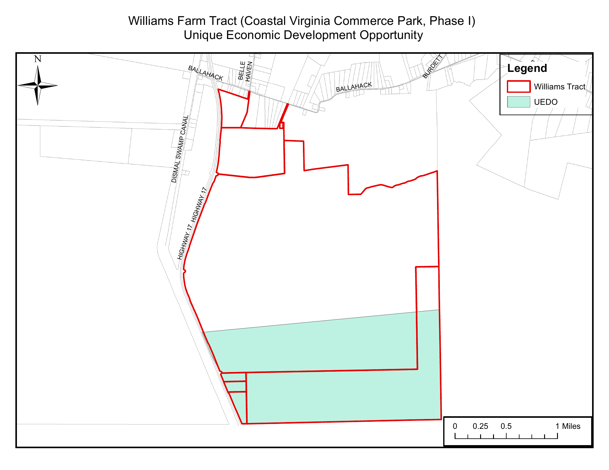
The City’s official map identifies the approximately 1,420-acre southern phase designated for unique economic-development use within the larger Williams Farm property.
Decades in the making
The milestones below are grounded in government planning records, public reports, and contemporaneous news coverage.
A farm at remarkable scale
F.T.W. & Sons Farms begins operating the property as a crop farm. Roughly 4,000 contiguous Virginia acres become a singular feature of southern Chesapeake.
Long-range public planning
An Urban Land Institute Advisory Services Panel finds strategic development potential—but not a short-term path—because infrastructure and environmental questions remain unresolved.
A place in the City’s future
Chesapeake’s comprehensive plan identifies the Williams Tract as an Auto-Oriented Major Activity Center on its preferred long-range development map.
From possibility to policy
The City creates its Unique Economic Development Opportunity policy, requests megasite recognition, secures site-characterization support, extends the Route 17 corridor overlay, and designates the first phase as a UEDO.
The Gateway Virginia Innovation District
City Council approves a comprehensive-plan amendment establishing the innovation-district designation for the approximately 1,420-acre first phase.
Public planning milestone
City Council approves an updated public planning framework for a portion of the property.
Earlier public planning activity
Public records describe earlier planning activity associated with the former Coastal Virginia Commerce Park.
The Praetorian Park Possibility
A strategy to build on decades of public planning, environmental study, and regional ambition to develop an innovation hub for the future.
A succession of ambitious ideas
Across several decades, the property was associated with concepts that reflected the economic priorities of their time.
Destination, golf & resort
Institutional recollections describe Disney-related, golf, resort, and entertainment discussions. Their precise scope and timing remain under documentary review.
Automotive & manufacturing
Volkswagen and other automotive opportunities have been recalled, while later public strategies explicitly positioned the tract for major manufacturing users.
Semiconductors & advanced industry
By 2022–23, public officials were positioning Coastal Virginia Commerce Park for semiconductor, microchip, electric-vehicle, and other advanced-manufacturing prospects.
Evidence before legend
Public planning & investment
The City and Commonwealth studied, designated, rezoned, and funded the site through formal public actions spanning more than two decades.
Dreamland & early concepts
Disney-related, Volkswagen, golf, resort, and entertainment concepts remain attributed institutional recollections until archival records establish their precise scope.
Praetorian Park
Current development plans are a forward-looking chapter and remain subject to diligence, engineering, utility coordination, applicable approvals, and change.
Development was never uncontested.
Residents and environmental stakeholders raised questions about wetlands, hydrology, drinking water, farmland conversion, traffic, wildlife movement, military compatibility, and public utility costs. Those concerns shaped later requirements for coordinated agency review, buffers, corridors, stormwater planning, and a comprehensive master plan.
Public planning context
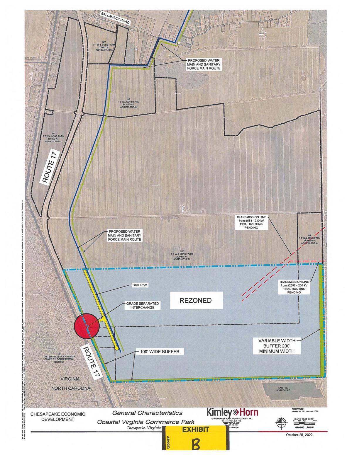
Public exhibits provide general historical and geographic orientation.
Read the public record
Primary sources are prioritized. Reporting is used for transaction context, public response, and statements made at the time.
A history still being written.
Praetorian Park enters a story shaped by agriculture, civic ambition, public debate, and sustained institutional work. Qualified parties can request additional project information or coordinate a conversation with the team.
Connect with the Park →